In one scenario, an officer pursues and overtakes two suspects in an alley, but as she approaches them, the officer realizes her portable radio became detached during the chase.
In another, officers fan out around an active crime scene. They can’t see one another, but their need to swiftly and effectively position themselves around the area is paramount to containing potential casualties and apprehending suspects.
In a third situation, an officer finds himself lost in an unfamiliar setting, unable to accurately identify his own location or convey it to the command center.
All of these circumstances are realistic—and not entirely uncommon—examples of the challenges law enforcement professionals can face in the field. Fortunately, there is a solution to all three scenarios and others like them: the global positioning system (GPS).
The satellite navigation system is well known to police and civilians alike for pinpointing locations and determining travel directions. GPS has gained traction in the public safety sector primarily as a tool for tracking and monitoring vehicles.
That remains a central function, with a number of vendors offering GPS-based vehicle and fleet management solutions. However, a new capability is emerging, in which GPS monitors not just vehicles but also individual officers.
“Our agencies love how we track officers in and out of their vehicles,” said Alex Lobodiak, director of business development for GeoSafe, a company based in Norman, Oklahoma. “Most agencies are just tracking inside the vehicles. GPS allows agencies to track their most valuable asset: the officer.”1
On Foot
Most agencies are familiar with body-worn cameras (BWCs), but one company is taking the concept into new territory: body-worn computers.
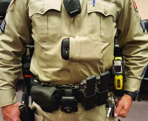
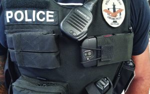
Visual Labs, Inc., headquartered in Menlo Park, California, has developed the Smartphone Body Camera, a device that affixes to the uniform and performs a variety of functions along with the familiar video and photography capabilities. One of those functions is GPS-based location services.
“The main difference is we’re using a smartphone as a body-worn computer,” said Alexander Popof, Visual Labs’ chief operating officer. “You get the functionality of a body-worn camera, but because it’s a computer, you get phone calls and other things. It’s a fully functioning smartphone.”2

The Visual Labs version of the BWC can also take audio recordings and bookmark important moments. Any Android smartphone can be converted into a Smartphone Body Camera without affecting any existing smartphone functions such as email.
“There’s a natural preconception that if I have a smartphone, I need to have it in my hand, but that’s not the case,” Popof said. “The officer only has to tap a button to start and stop a video recording.”
According to Popof, recently, an active shooter situation unfolded inside a building, and multiple officers responded. As they attempted to triangulate the shooter’s location inside that building, officers were directed into specific positions from the command center. The department was a Visual Labs client, and each officer entered the situation equipped with the Smartphone Body Cam-era. Ultimately, the high-level strategic direction that the devices helped make possible allowed officers to apprehend the suspect with no casualties.
“The key thing is letting the dispatch or command staff know where an officer or multiple officers are during a crisis.”
“Active shooter in a building, sent multiple officers, someone is coordinating positions through a map,” Popof said.
“You could see outdoors to a 3–5 meter accuracy where they were in relation to other officers. Looking down from a bird’s eye view in real time—it’s potentially life-saving… The key thing is letting the dispatch or command staff know where an officer or multiple officers are during a crisis.”

Popof also gives the account of another officer who was not equipped with a GPS-enabled device, but whose radio became detached during foot pursuit. “The officer cornered them and had them at gunpoint and no way to communicate,” Popof said. “The command staff didn’t know where he was. He needed a helicopter to find him.”
The Smartphone Body Camera can result in up to 50 percent reductions in software and storage cost savings, according to Popof.
Like the Smartphone Body Camera, the GeoSafe Mobile tool performs several functions in addition to GPS. The tool, which is compatible with iPhone, iPad, and personal computers, integrates GPS tracking with computer-aided dispatch (CAD) data and can help police better collaborate with fire and EMS colleagues.
“It works well with law, fire, and EMS agencies,” Lobodiak said. “Users can filter out sensitive information, so they can roll GeoSafe out with other agencies. If they’re doing mutual aid and a police officer is the first person on the scene, EMS can see where to meet them.”
Lobodiak relays a story when GeoSafe Mobile helped an officer’s colleagues extricate him from a difficult situation. “An officer was engaged in a foot pursuit, pursued a suspect into the middle of a large field in the middle of nowhere,” Lobodiak said. “The closest landmark was a barn and that was a long way away. Because he was using GeoSafe, the dispatcher could see exactly where he was. There’s better situational awareness during foot pursuit.”
One GeoSafe client, Lobodiak said, reported that GeoSafe Mobile helped reduce crime in the client’s jurisdiction by 20 percent.
In the Vehicle
The reach of GPS is spreading beyond the vehicle, but the fleet remains an important and natural home for GPS, particularly in law enforcement. However, fleet management is changing as well. Constant technological advancements mean GPS can perform a number of functions beyond those with which it is typically associated.
“‘Where’s my vehicle at?’ has gone by the wayside,” explained Michael Hughes, president and CEO of Track Star International, a company based in Charlotte, North Carolina, that provides GPS-based solutions for several sectors, including law enforcement. “Now people need and expect to know a lot more… In today’s world, more information is needed. They want to know more about their vehicles.”3
Track Star AVLS is a prime example of a GPS system that meets the need for more information. Along with location information, the tool provides a steady stream of data and notifications on vehicle operating status and other information.
As a result, Track Star can help agencies on various fronts, including fuel economy, thanks to maintenance indicators, fuel usage, and idling characteristics that the tool can report. The product also provides a “panic button” for officers, which triggers immediate location identification when activated.
A true differentiator for Track Star AVLS, Hughes said, is that the solution and its tools are housed in internal department computers, which helps resolve potential chain of custody issues and allows the data to be admissible in court if needed. This can be valuable, for example, at times when data on vehicle speed are part of a case, Hughes said.
Hughes points to research concluding that comprehensive GPS-based fleet management can save agencies approximately $1,300 per year in operating costs. At the same time, Hughes said that Track Star clients value other aspects of the solution as well.
“They see improvement in two areas,” Hughes said. “There is officer safety, which is the most important thing, but there’s also a community benefit. There is better documentation of patrol patterns and things like that.”
Different services address different challenges, and the solutions provided by GoFleet, based in Ontario, Canada, are no exception. The company’s GO7 model tracks vehicles with GPS, but also can easily integrate with other services, such as Garmin, which allows for two-way communication between drivers and dispatchers.
“Police officers model behavior behind the wheel on the road,” said Matthew De Faria, GoFleet’s director of sales. “This tracks the behavior when the sirens aren’t on, things like harsh braking, cornering, and aggressive driving.”4
GPS can also be a game changer when it comes to vehicle pursuits. StarChase, based in Virginia Beach, Virginia, produces solutions that can be utilized for managing various high-risk traffic scenarios such as DUIs, vehicle thefts, human trafficking, and fleeing suspects.
A simple hardware array allows officers to arm the system when a suspicious vehicle has been identified, use a laser sighting mechanism to target the vehicle, and then create a GPS “tag” for that vehicle that allows the officer to track the vehicle to the conclusion of the incident. To date, law enforcement has created more than 10,000 tags using StarChase.
“You can bring vehicles in, in a much calmer way,” said StarChase president Trevor Fischbach. “It avoids all the risks that you could think of during a pursuit.”5
As GPS tools continue to improve and new capabilities are added, law enforcement users can expect to reap the benefits in areas such as convenience, situational awareness, communication, officer safety, traffic safety, and incident management—in addition to knowing where they are. d
Notes:
1 Alex Lobodiak (director of business development, GeoSafe), telephone interview, December 27, 2018.
2 Alexander Popof (chief operating officer, Visual Labs, Inc.), telephone interview, December 27, 2018.
3 Michael Hughes (president, chief executive officer, Track Star International), telephone interview, November 30, 2018.
4 Matthew De Faria (director of sales, GoFleet), telephone interview, November 29, 2018.
5 Trevor Fischbach (president, StarChase), telephone interview, November 30, 2019.
SOURCE LIST |
|
Please cite as
Scott Harris, “GPS Devices Help Officers on Foot as Well as in Vehicles,” Product Feature, Police Chief 86, no. 2 (2019): 48–50.


